
Environmental Justice and the Local Effects of Glacier Melt
A Case Study in the Peruvian Cordillera Huayhuash
by Holly Moulton, Tinker grantee; PhD candidate
Environmental Studies Program
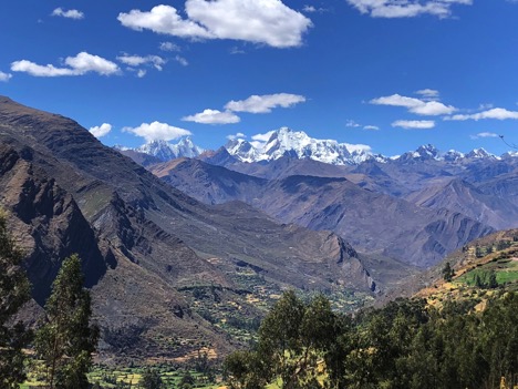
My field research focused on communities in the Cordillera Huayhuash, a highly glaciated mountain range in the Central Peruvian Andes—which contains 70 percent of the world’s tropical glaciers. The Cordillera Huayhuash is home to 20,000 people concentrated in nine main rural towns. It is a microcosm of larger social and environmental issues playing out across Peru and Latin America, including mining, conservation, rural development, indigenous rights and climate change concerns. For my dissertation, I hoped to use the Cordillera Huayhuash as a case study to understand how adaptations to glacier melt—in particular, the cascading social, environmental and hydrological effects of glacier recession—affect the equitable distribution of resources and spawn social justice concerns.
In order to lay groundwork for future research, I conducted initial field work in the Cordillera Huayhuash in August 2018 to establish connections with a variety of community members and document the lived experiences of glacier melt in the region. Through my research, the primary questions I sought to answer were: what are the effects of glacier melt on the livelihoods of downstream, rural communities in the Cordillera Huayhuash, and what community-based or externally-supported adaptation measures are already underway? In order to address these questions, I planned to spend one week circumnavigating the Huayhaush range to understand the physical and social dynamics of the broader region, five days interviewing residents of the Pocpa and Llamac communities, and three to five days before and after the trip interviewing glaciologists, national park officials, and non-governmental organization (NGO) representatives in the urban center of Huaraz. There were some changes to the itinerary that I actually conducted based on changing conditions on the ground and some unforeseen circumstances.
The Tinker Field Research Grant was designed to help me accomplish the following specific pre-dissertation goals: 1) Determine and aggregate the principal glacier-melt related concerns of 10 community members in Pocpa and Llamac, two of the more accessible communities in the Huayhuash, so as to create a more inclusive and locally relevant dissertation project; 2) interview a local tour guide, representatives from the Peruvian National Park (SERNANP) and Glaciology and Water Resources (UGRH) offices in order to understand technical and professional perspectives of glacier melt in the Huayhuash; 3) document initial observations of key glacier melt-related social, physical and environmental changes deemed significant by local communities, guides and experts, in order to establish a spatial baseline for my future field work.
Previous research opportunities in the region allowed me to build a base of knowledge for this project, and to establish the appropriate connections, experiences, and contextual understandings to deploy Tinker Summer Grant research.
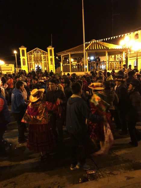
During summer 2019, I informally interviewed ten people for the project. I adapted my original plan and focused on people in the town of Chiquian, which is the largest city in the Ancash region of the Huayhuash and the major first-entry point for individuals entering the range from Ancash. Chiquian formed the geographic basis of my interviews. This change resulted from unforeseen circumstances that prohibited me from circumnavigating the range.
In Chiquian, I stayed with friends of a photographer who has spent decades in the region. He connected me to the owner of a local hostel, who also happened to be running for local office, and was heavily involved in community organizing and affairs. Manuel provided invaluable information about some of the key issues in the region, including water infrastructure and sanitation, and was able to point me towards several people to speak with in town about my research. These people included a local guide named Joel, who is one of the few guides based in Chiquian (rather than Huaraz) who frequently brings tourists into the range. As a result of his years of experience, I was able to get a good sense of the observed changes in ice, water cycles, agriculture, and tourism in the area, from the perspective of someone who grew up at the edge of the mountain range. Additionally, I interviewed several small business owners and a family, who I ended up staying with and eating meals with everyday.
Through my interviews, I was able to locate the correct office to gather demographic information for the region. Although there is a municipal government center in Chiquian, many of the necessary records are actually held in Huaraz, since demographic information is gathered at the regional level. The interviews also furnished valuable information about livelihoods, local cultures, and history. This was augmented by the fact that elections were occurring in October of this year, meaning that most people of the town were talking about items that were critical for candidates to address in the upcoming election. I was able to stop by the local electoral office and gather lists of the candidates and the key issues they were hoping to address. Moreover, I collected informal information about livelihoods in the region, and was able to corroborate this by talking with a variety of small business owners (including bus operators, restaurant owners, farmers, and hotel owners). Combined with information that I received from talking to Timothy Norris, who conducted his doctoral research in the region and started a mapping business in the Huayhuash range, I was able to gather all of the demographic, cultural, and historical data that I needed for this stage of research.
I conducted interviews with local guides in Huaraz, Pocpa, and Chiquian. The interviews yielded interesting place-specific information that highlighted the differences in perceived and measured environmental changes between the Cordillera Blanca and the Huayhuash, and between different geographic regions in the Huayhuash.
Despite the fact that my itinerary changed, I was able to cobble together the maps and data that I needed regarding the physical and environmental features of the region, as well as the town locations. I was able to do this by traveling to Chiquian, Pocpa, and Llamac, and sourcing as many different maps from guides, scientists, tourists, and local businesses as possible. I hope to look at the differences between these maps to glean different types of data (i.e. agricultural vs. glaciological information) based on the map authors.
I was able to speak with the former head of SERNANP and various ANA and UGRH representatives while in Huaraz. They provided key documents about the Cordillera Huayhuash, pointed me towards sources for the additional documentation that I needed, and provided their perspective on the social and physical effects of climate change on glaciers, water, and society.
One of the most important findings from this research was actually something that I did not, in fact, find: the voices of women in the region. I realized that almost all of the dialogues that I was having with scientists, local government officials, and business owners were with men. This contrasts with the informal conversations that I had with women in “care” positions, such as the family that fed me delicious meals every day in Chiquian and was sad to see me go, and the woman working on the bus from Huaraz to the Huayhuash who talked to me extensively and provided me with directions and contacts for when I arrived in the area. The voices of women were often “relegated” to informal or day-to-day conversations, whereas men in positions of power were willing to talk about projects they were a part of or how their career is connected to larger issues of environmental change. This, again, was perhaps the most important observation that surfaced from my field notes.
Above all, people in communities in the Cordillera Huayhuash did not seem deeply perturbed by melting glaciers and changing hydrological conditions. Actually, many of the tourists that I spoke with told me that there appeared to be plentiful water, and few interviewees spoke of absolute water scarcity. What they did talk about was a lack of clean and efficient water infrastructure, as well as contamination from local mining operations. These were frequently mentioned above and beyond climatological or glaciological changes. Most interviewees were concerned above all with their day-to-day livelihoods, including a diverse range of occupations from guiding to farming to hostel administration. This helped to reinforce much of the literature that I have been reading that climate and environmental justice concerns often revolve around issues that are more intimately connected to daily sources of vulnerability rather than looming climate risks.
The interviews, data, maps, historical documents, and prior research documents that I gathered will be invaluable as I continue to evaluate the Cordillera Huayhuash as a case study for my dissertation. Regardless of whether this specific site makes sense, I now have a much better idea of: 1) the major government and scientific agencies and personalities in the region; 2) the dominant voices in the narrative of climate change and glacier loss in the region, and; 3) some of the real challenges that people face in remote regions of the Huayhuash Range that would have been impossible to glean without fieldwork. Despite the challenges of this work, the Tinker grant was critical for furthering my understanding of this unique area and the environmental justice issues with which people, and particularly women, are grappling.